Content note: Japanese wartime booklet map with caricatured American and British figures, shown as published. This object is shown as it was published. Why
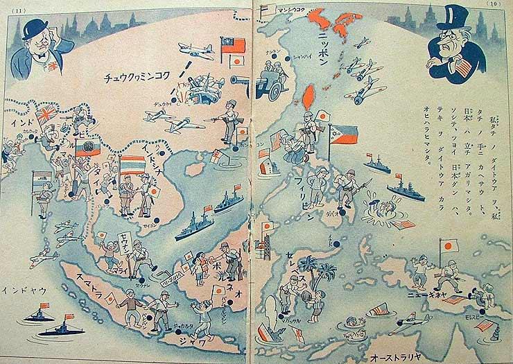
Japanese children's booklet map of the Greater East Asia Conference (Japan, 1943)
Double-page pictorial map: Japan in red at top right, Asian lands as cartoon scenes of Japanese soldiers beside smiling locals with flags, and sinking ships under British and American flags; caricatured Western figures glower from the corners. The tell: the whole region is shown welcoming and every Western presence defeated; the first-person 'our Greater East Asia' in the text folds the peoples shown into the Japanese cause, and no occupation or resistance appears.
Propaganda techniques used in this print
- Date
- 1943
- Period
- Second World War
- Made by
- Empire of Japan (booklet published for the Greater East Asia Conference, Tokyo, November 1943; publisher not named on the spread)
Full record
Region, Country, Medium, Issuer type, Regime, Leader, Audience, Purpose, Themes, Event, Source, Rights
- Region
- East Asia
- Country
- Empire of Japan
- Medium
- Issuer type
- State
- Regime
- Showa Japan
- Leader
- Hideki Tojo
- Audience
- Domestic public
- Purpose
- Persuade or win support
- Themes
- Empire and colonialism, War and the military
- Event
- Greater East Asia Conference 1943
- Leader
- Hideki Tōjō
- Source
- Unidentified Source blurred: contractors, cutouts, buried disclosure
- Source
- Wikimedia Commons, retrieved October 11, 2026
- Rights
- Public domain (Commons tags PD-Japan-organization, PD-1996; 1943 Japanese organisational booklet)
Japanese propaganda booklet fragment, 1943 (publisher given by Commons as the Tokyo Conference); via Wikimedia Commons
Text on the object
Original (Japanese) · read from the image, not independently checked
ニッポン

私タチノダイトウア ヲ、私タチノ手ニカヘサウト、日本ハ立チ上ガリマシタ。ソシテ、ツヨイ日本グンハ、テキ ヲ ダイトウア カラ オヒハラヒマシタ。
Japan

Japan stood up to take our Greater East Asia back into our hands. And the strong Japanese army drove the enemy out of Greater East Asia.
Read from the 740 px image; the small place-name labels on the map (Saigon, Java, Philippines and others) were not transcribed and the right-hand paragraph is only partly crisp, so a few particles may differ from the print. Translation is a literal machine translation by Claude, not checked by a fluent reader.