Content note: Census box lists the Union of South Africa's population under the printed categories Europeans, Natives, Coloured and Asiatics. This object is shown as it was published. Why
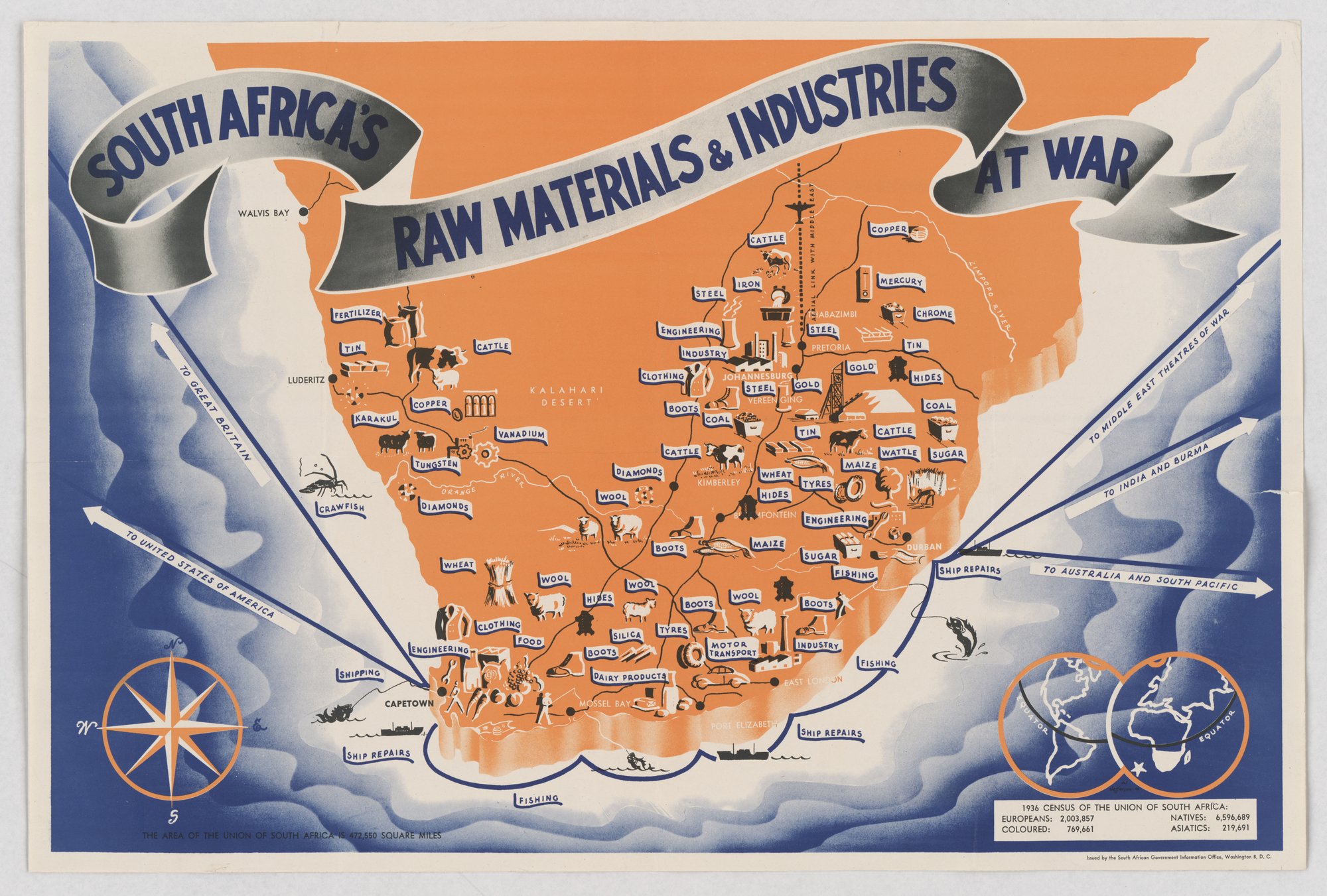
South Africa's raw materials & industries at war
Pictorial map of the Union of South Africa in orange, with small labelled icons for products and industries (gold, diamonds, wool, wheat, steel, ship repairs and others) and arrows pointing to Great Britain, the United States, the Middle East, India and Burma, and Australia. The tell for card-stacking is that only contributions and output are shown. A 1936 census box lists population by category.
Propaganda techniques used in this poster
- Date
- 1941
- Period
- Second World War
- Made by
- South African Government Information Office, Washington, D.C.
- Region
- Sub-Saharan Africa
- Country
- South Africa
- Medium
- Poster
- Issuer type
- State
- Regime
- Smuts Government
- Leader
- Jan Smuts
- Audience
- Foreign public
- Purpose
- Persuade or win support
- Themes
- Economy and finance, War and the military, Empire and colonialism
- Event
- World War II
- Source
- Identified Openly sourced: the speaker is who they say they are
- Source
- U.S. National Archives and Records Administration, Record Group 44, World War II Posters, retrieved October 4, 2026
- Rights
- Public domain (U.S. government work)
South African Government Information Office. National Archives and Records Administration, RG 44, 44-PA-1783 (NAID 515456).
Text on the object
SOUTH AFRICA'S
RAW MATERIALS & INDUSTRIES AT WAR

TO GREAT BRITAIN
TO UNITED STATES OF AMERICA
TO MIDDLE EAST THEATRES OF WAR
TO INDIA AND BURMA
TO AUSTRALIA AND SOUTH PACIFIC

WALVIS BAY, LUDERITZ, KALAHARI DESERT, PRETORIA, JOHANNESBURG, VEREENIGING, KIMBERLEY, BLOEMFONTEIN, DURBAN, EAST LONDON, PORT ELIZABETH, MOSSEL BAY, CAPETOWN, ORANGE RIVER, LIMPOPO RIVER, AERIAL LINK WITH MIDDLE EAST, [name near Pretoria: BABAZIMBI, partly legible]

Product and industry labels on the map: FERTILIZER, TIN, CATTLE, KARAKUL, COPPER, VANADIUM, TUNGSTEN, DIAMONDS, CRAWFISH, WOOL, WHEAT, CLOTHING, FOOD, ENGINEERING, SHIPPING, SHIP REPAIRS, FISHING, BOOTS, HIDES, SILICA, TYRES, MOTOR TRANSPORT, DAIRY PRODUCTS, INDUSTRY, COAL, STEEL, IRON, MERCURY, CHROME, GOLD, SUGAR, MAIZE, WATTLE.

EQUATOR (twice, on the inset globes)
THE AREA OF THE UNION OF SOUTH AFRICA IS 472,550 SQUARE MILES

1936 CENSUS OF THE UNION OF SOUTH AFRICA:
EUROPEANS: 2,003,857
NATIVES: 6,596,689
COLOURED: 769,661
ASIATICS: 219,691

Issued by the South African Government Information Office, Washington 8, D. C.
[compass points:] N, S, W, E