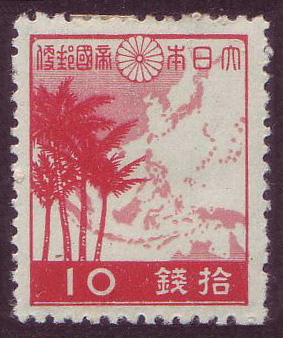
10 sen stamp with a map of the Greater East Asia Co-Prosperity Sphere (1942)
A red Japanese 10 sen stamp. The imperial chrysanthemum crest sits at top centre with the postal inscription beside it; a pale silhouette map of east and southeast Asia with its island chains fills the right side and three palm trees stand at left. The tag rests on the placement of the crest and the national postal name directly over a map that the Commons description identifies as the Co-Prosperity Sphere (transfer); the map carries no labels, so the association rests on position and imagery alone.
- Date
- December 1, 1942
- Period
- Second World War
- Made by
- Imperial Japanese Ministry of Communications (逓信省), postal authority of the Empire of Japan
- Region
- East Asia
- Country
- Empire of Japan
- Medium
- Stamp
- Issuer type
- State
- Regime
- Showa Japan
- Leader
- Hideki Tojo
- Audience
- Domestic public
- Purpose
- Persuade or win support
- Event
- World War II
- Techniques
- Transfer
- Leader
- Hideki Tōjō
- Source
- Identified Openly sourced: the speaker is who they say they are
- Source
- Wikimedia Commons (scan of the stamp, stamp collection of the uploader Carpkazu), retrieved October 2, 2026
- Rights
- Public domain (Commons: PD-Japan-oldphoto + PD-1996; 1942 government stamp, author unknown)
Imperial Japanese Ministry of Communications, 10 sen Greater East Asia map stamp, 1942, public domain, via Wikimedia Commons
Text on the object
大日本帝國郵便
10
拾錢
Great Japan Imperial Postage
10
Ten sen
Read from the 283 by 338 pixel scan. The top inscription runs right to left across the chrysanthemum crest (大日本 to the right of it, 帝國郵便 to the left); the denomination at the foot reads 10 at left and 錢拾 at right, that is 拾錢 read right to left. The translation is machine-made and not checked by a fluent reader of Japanese.