World Map (Khmer poster distributed in Cambodia)
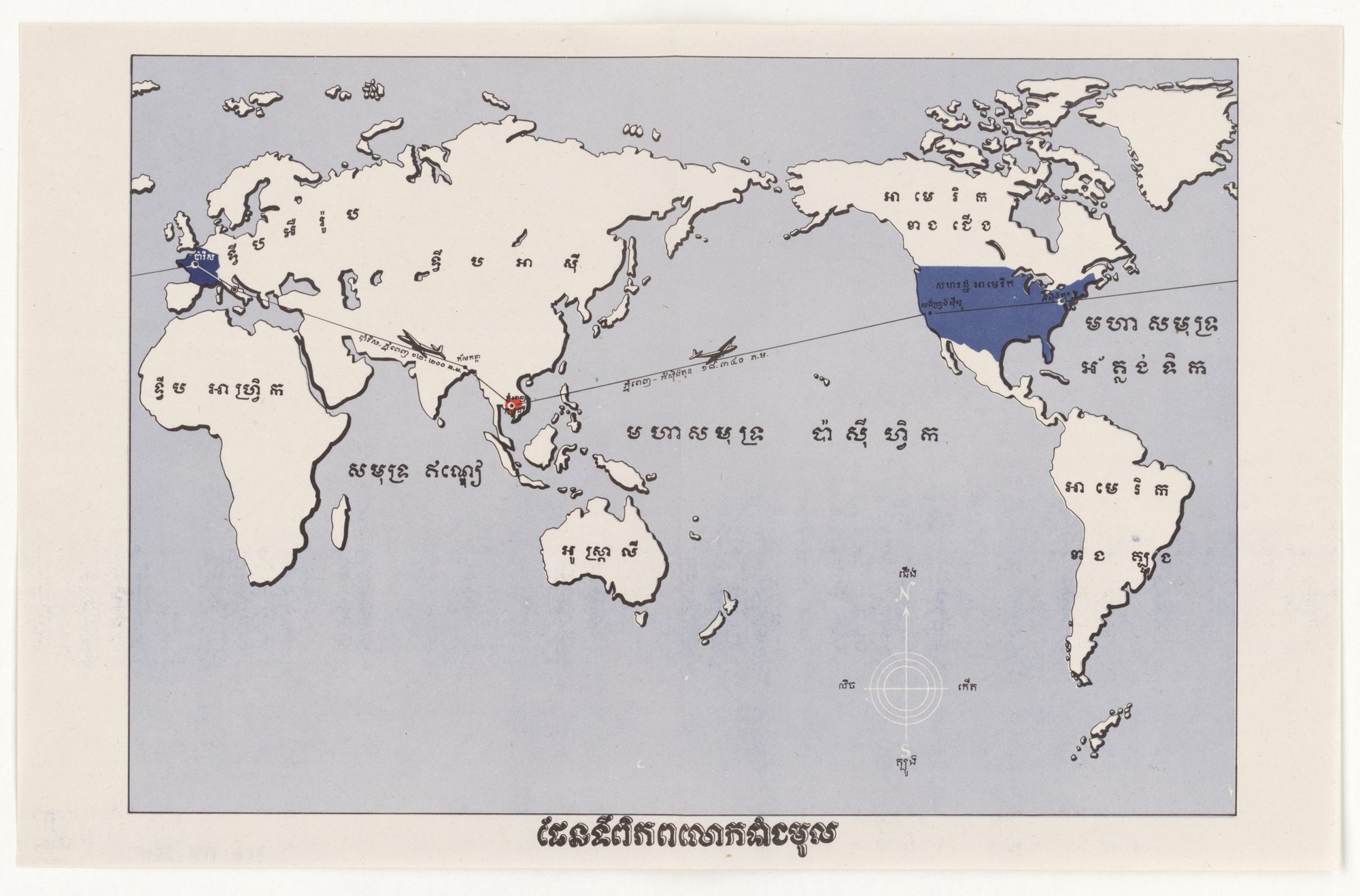
A Khmer-labelled world map centred on Southeast Asia, with the United States and France filled in blue and Cambodia marked in red. Two thin lines with aeroplane symbols join Phnom Penh to Paris and to Washington, each carrying a printed distance. The sheet shows where Cambodia lies in relation to the two countries. The tell is card-stacking by emphasis: only these three places are coloured and linked, and no argument is stated in words.
Propaganda techniques used in this poster
- Date
- March 13, 1953
- Period
- Cold War
- Made by
- U.S. Information Agency (predecessor: State Department International Information and Educational Exchange Program), Propaganda Posters Distributed in Asia series
- Region
- North America
- Country
- United States
- Medium
- Poster
- Issuer type
- State
- Regime
- Eisenhower Administration
- Leader
- Dwight D. Eisenhower
- Audience
- Foreign public
- Purpose
- Warn or inform
- Theme
- Media and information
- Event
- Cold War
- Source
- Unidentified Source blurred: contractors, cutouts, buried disclosure
- Source
- U.S. National Archives (NARA), Record Group 306, Propaganda Posters Distributed in Asia, retrieved October 3, 2026
- Rights
- Public domain (U.S. government work; NARA RG 306)
U.S. Information Agency / Department of State, March 13, 1953. National Archives, Record Group 306 (NAID 5730165, 306-PPA-264).
Text on the object
ផែនទីពិភពលោក[illegible: remainder of title]

[Map labels:]
ទ្វីប អឺរ៉ុប
ទ្វីប អាស៊ី
ទ្វីប អាហ្រ្វិក
អាមេរិក ខាងជើង
សហរដ្ឋ អាមេរិក
មហា សមុទ្រ អត្លង់ទិក
អាមេរិក ខាងត្បូង
មហាសមុទ្រ ប៉ាស៊ីហ្វិក
សមុទ្រ ឥណ្ឌា
អូស្ត្រាលី
ប៉ារីស
[illegible small labels: Phnom Penh, Washington, and two flight-distance captions]
ជើង / ត្បូង / កើត / លិច
[Title:] World map [remainder of title illegible]
[Map labels:] Europe continent; Asia continent; Africa continent; North America; United States of America; Atlantic Ocean; South America; Pacific Ocean; Indian Ocean; Australia; Paris. [Small labels, illegible: Phnom Penh; Washington; two flight-route distance captions.] [Compass:] North / South / East / West. (Khmer reading is partial and uncertain; the specific distances printed on the two flight routes could not be read.)
Khmer script read from a downscaled image; label spellings and spacing are uncertain and the title is incomplete.