Germany: Political Divisions
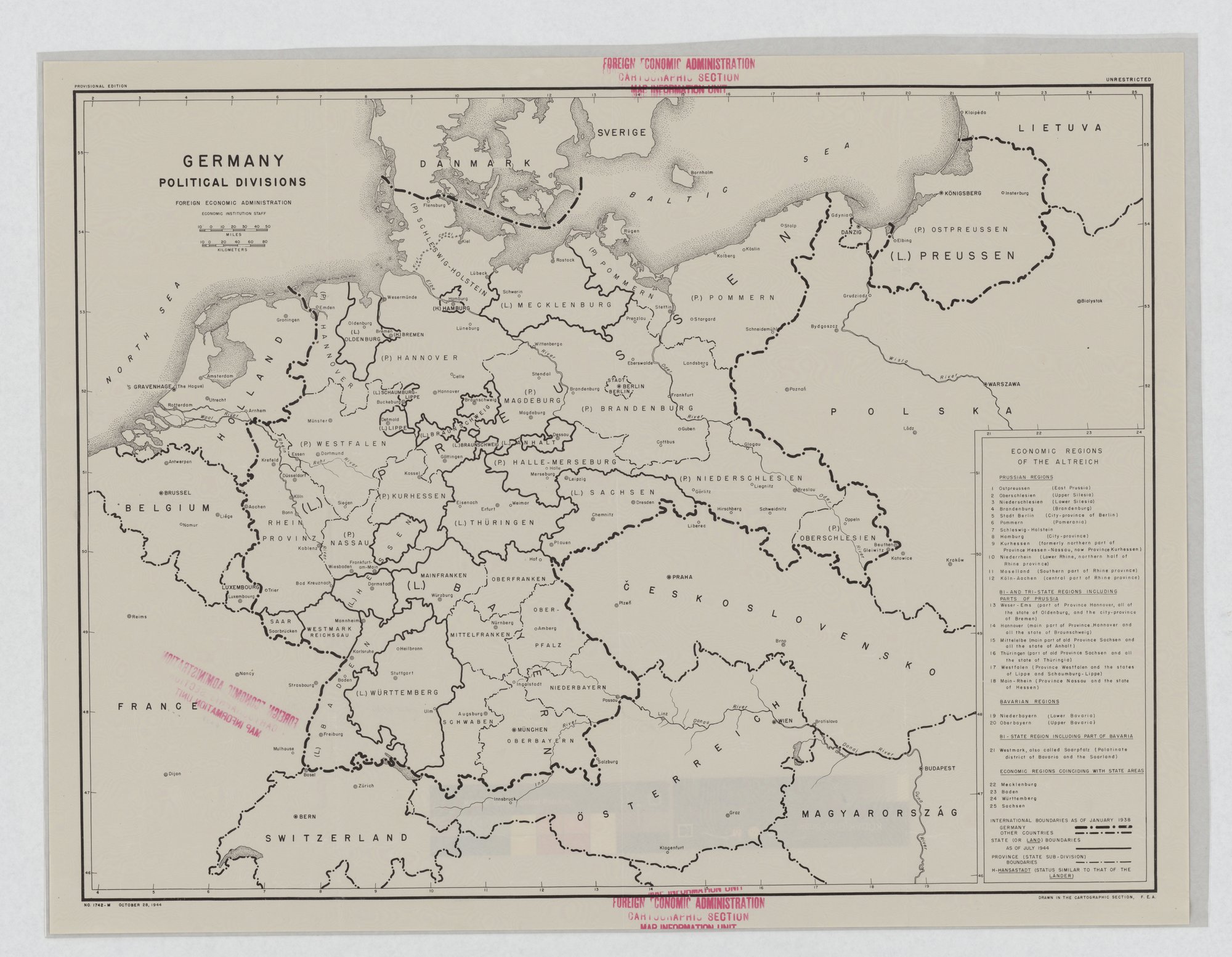
Black-and-white map of Germany with state and province boundaries as of July 1944, international boundaries as of January 1938, and a key to 25 economic regions. It is a reference map; the technique is faint, the choice of 1938 borders and German-language place names as a framing.
Propaganda techniques used in this poster
- Date
- 1944
- Period
- Second World War
- Made by
- Foreign Economic Administration, Economic Institution Staff, Cartographic Section
- Region
- North America
- Country
- United States
- Medium
- Poster
- Issuer type
- State
- Regime
- Roosevelt Administration
- Leader
- Franklin D. Roosevelt
- Audience
- Domestic public
- Purpose
- Warn or inform
- Themes
- War and the military, Economy and finance
- Event
- World War II
- Regime
- Roosevelt administration
- Leader
- Franklin D. Roosevelt
- Source
- Identified Openly sourced: the speaker is who they say they are
- Source
- U.S. National Archives and Records Administration, Record Group 44, World War II Posters, retrieved October 4, 2026
- Rights
- Public domain (U.S. government work)
Foreign Economic Administration. National Archives and Records Administration, RG 44, 44-PA-858 (NAID 514352).
Text on the object
GERMANY
POLITICAL DIVISIONS
FOREIGN ECONOMIC ADMINISTRATION
ECONOMIC INSTITUTION STAFF
PROVISIONAL EDITION
UNRESTRICTED
ECONOMIC REGIONS OF THE ALTREICH
PRUSSIAN REGIONS: 1 Ostpreussen (East Prussia); 2 Oberschlesien (Upper Silesia); 3 Niederschlesien (Lower Silesia); 4 Brandenburg (Brandenburg); 5 Stadt Berlin (City-province of Berlin); 6 Pommern (Pomerania); 7 Schleswig-Holstein; 8 Hamburg (City-province); 9 Kurhessen (formerly northern part of Province Hessen-Nassau, now Province Kurhessen); 10 Niederrhein (Lower Rhine, northern half of Rhine province); 11 Moselland (Southern part of Rhine province); 12 Köln-Aachen (central part of Rhine province)
BI- AND TRI-STATE REGIONS INCLUDING PARTS OF PRUSSIA: 13 Weser-Ems (part of Province Hannover, all of the state of Oldenburg, and the city-province of Bremen); 14 Hannover (main part of Province Hannover and all the state of Braunschweig); 15 Mitteleibe (main part of old Province Sachsen and all of Anhalt); 16 Thüringen (part of old Province Sachsen and all the state of Thüringia); 17 Westfalen (Province Westfalen and the states of Lippe and Schaumburg-Lippe); 18 Main-Rhein (Province Nassau and the state of Hessen)
BAVARIAN REGIONS: 19 Niederbayern (Lower Bavaria); 20 Oberbayern (Upper Bavaria)
BI-STATE REGION INCLUDING PART OF BAVARIA: 21 Westmark, also called Saarpfalz (Palatinate district of Bavaria and the Saarland)
ECONOMIC REGIONS COINCIDING WITH STATE AREAS: 22 Mecklenburg; 23 Baden; 24 Württemberg; 25 Sachsen
INTERNATIONAL BOUNDARIES AS OF JANUARY 1938: GERMANY / OTHER COUNTRIES
STATE (OR LAND) BOUNDARIES AS OF JULY 1944
PROVINCE (STATE SUB-DIVISION) BOUNDARIES
H-HANSASTADT (STATUS SIMILAR TO THAT OF THE LÄNDER)
Map labels (selection, not exhaustive): DANMARK, SVERIGE, LIETUVA, POLSKA, ČESKOSLOVENSKO, ÖSTERREICH, MAGYARORSZÁG, SWITZERLAND, FRANCE, BELGIUM, HOLLAND, LUXEMBOURG; German states and provinces including (P) Hannover, (L) Preussen, (L) Bayern, (L) Sachsen, (L) Württemberg
NO. 1742-M OCTOBER 28, 1944
DRAWN IN THE CARTOGRAPHIC SECTION, F.E.A.
[stamp: FOREIGN ECONOMIC ADMINISTRATION CARTOGRAPHIC SECTION MAP INFORMATION UNIT]