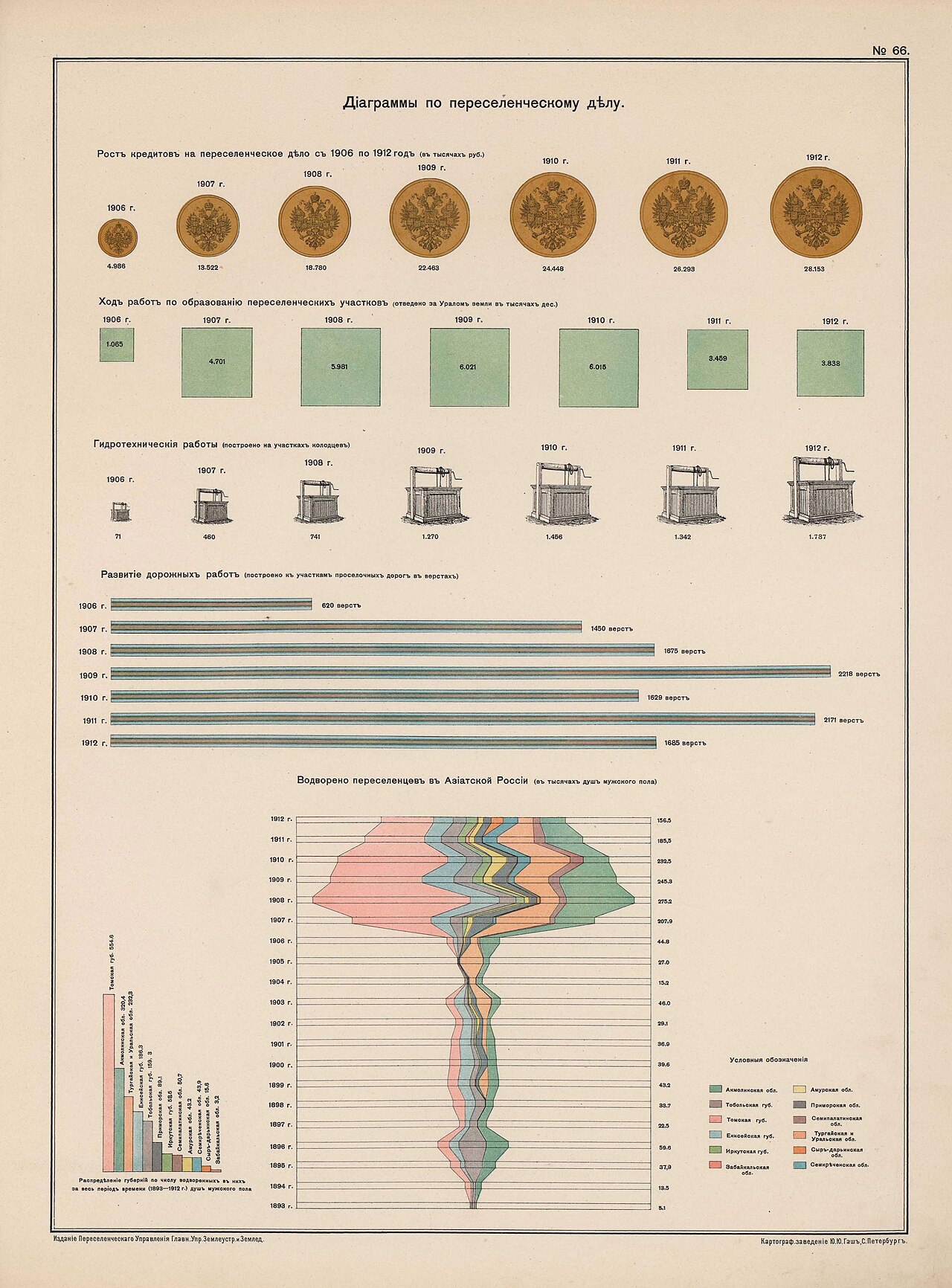
Diagrams of the resettlement work, plate 66 of the Atlas of Asiatic Russia (1914)
A colour plate of pictograms: gold coins stamped with the imperial double-headed eagle grow in size for credits from 1906 to 1912, green squares show land allotted east of the Urals, well-heads and road bars show works built, and a large stacked-band chart counts settlers placed in Asiatic Russia. The tell: only the administration's inputs and the count of settlers placed are drawn, sized so that the coins, wells and bands read as growth; nothing on the sheet shows returning migrants, costs or land already in use.
- Date
- 1914
- Period
- Pre-1914
- Made by
- Resettlement Administration (Pereselencheskoe upravlenie), Main Administration of Land Organisation and Agriculture, Russian Empire; printed by Yu. Yu. Gash, St Petersburg
- Region
- Eastern Europe and Eurasia
- Country
- Russian Empire
- Medium
- Issuer type
- State
- Regime
- Russian Empire
- Leader
- Nicholas II
- Audience
- Domestic public
- Purpose
- Persuade or win support
- Themes
- Empire and colonialism, Migration, Economy and finance
- Event
- Russian Peasant Resettlement To Siberia
- Techniques
- Card stacking
- Source
- Identified Openly sourced: the speaker is who they say they are
- Source
- Wikimedia Commons (reproducing the 1914 Atlas of Asiatic Russia), retrieved September 29, 2026
- Rights
- Public domain (published St Petersburg 1914, before 1931; Commons PD-RusEmpire)
Resettlement Administration, St Petersburg, 1914 (M. A. Tsvetkov, chief map editor); via Wikimedia Commons.
Text on the object
№ 66.
Діаграммы по переселенческому дѣлу.

Ростъ кредитовъ на переселенческое дѣло съ 1906 по 1912 годъ (въ тысячахъ руб.)
1906 г. 4.986; 1907 г. 13.522; 1908 г. 18.780; 1909 г. 22.463; 1910 г. 24.448; 1911 г. 26.293; 1912 г. 28.153

Ходъ работъ по образованію переселенческихъ участковъ (отведено за Ураломъ земли въ тысячахъ дес.)
1906 г. 1.065; 1907 г. 4.701; 1908 г. 5.981; 1909 г. 6.021; 1910 г. 6.015; 1911 г. 3.459; 1912 г. 3.838

Гидротехническія работы (построено на участкахъ колодцевъ)
1906 г. 71; 1907 г. 460; 1908 г. 741; 1909 г. 1.270; 1910 г. 1.456; 1911 г. 1.342; 1912 г. 1.787

Развитіе дорожныхъ работъ (построено къ участкамъ проселочныхъ дорогъ въ верстахъ)
1906 г. 620 верстъ; 1907 г. 1450 верстъ; 1908 г. 1675 верстъ; 1909 г. 2218 верстъ; 1910 г. 1629 верстъ; 1911 г. 2171 верстъ; 1912 г. 1685 верстъ

Водворено переселенцевъ въ Азіатской Россіи (въ тысячахъ душъ мужского пола)
1912 г. 156.5; 1911 г. 185.5; 1910 г. 232.5; 1909 г. 245.3; 1908 г. 275.2; 1907 г. 207.9; 1906 г. 44.8; 1905 г. 27.0; 1904 г. 15.2; 1903 г. 46.0; 1902 г. 29.1; 1901 г. 36.9; 1900 г. 39.6; 1899 г. 43.2; 1898 г. 33.7; 1897 г. 22.5; 1896 г. 59.6; 1895 г. 37.9; 1894 г. 13.5; 1893 г. 5.1

Распредѣленіе губерній по числу водворенныхъ въ нихъ за весь періодъ времени (1893—1912 г.) душъ мужского пола
[bar labels, values partly legible:] Томская губ. 554.6; Акмолинская обл. 320.4; Тургайская и Уральская обл. 232.3; Енисейская губ. 198.3; Тобольская губ. 159.3; Приморская обл. 89.1; Иркутская губ. 58.5; Семипалатинская обл. 50.7; Амурская обл. 43.2; Сыръ-дарьинская обл. [illegible]; Забайкальская обл. [illegible]

Условныя обозначенія:
Акмолинская обл.; Тобольская губ.; Томская губ.; Енисейская губ.; Иркутская губ.; Забайкальская обл.; Амурская обл.; Приморская обл.; Семипалатинская обл.; Тургайская и Уральская обл.; Сыръ-дарьинская обл.; Семирѣченская обл.

Изданіе Переселенческаго Управленія Главн. Упр. Землеустр. и Земледѣлія.
Картограф. заведеніе Ю. Ю. Гашъ, С.-Петербургъ.
No. 66.
Diagrams on the resettlement work.

Growth of credits for the resettlement work from 1906 to 1912 (in thousands of roubles)
1906: 4,986; 1907: 13,522; 1908: 18,780; 1909: 22,463; 1910: 24,448; 1911: 26,293; 1912: 28,153

Progress of work on forming settlement plots (land allotted beyond the Urals, in thousands of desyatinas)
1906: 1,065; 1907: 4,701; 1908: 5,981; 1909: 6,021; 1910: 6,015; 1911: 3,459; 1912: 3,838

Water-engineering works (wells built on the plots)
1906: 71; 1907: 460; 1908: 741; 1909: 1,270; 1910: 1,456; 1911: 1,342; 1912: 1,787

Development of road works (village roads built to the plots, in versts)
1906: 620; 1907: 1,450; 1908: 1,675; 1909: 2,218; 1910: 1,629; 1911: 2,171; 1912: 1,685

Settlers established in Asiatic Russia (in thousands of male souls)
1912: 156.5; 1911: 185.5; 1910: 232.5; 1909: 245.3; 1908: 275.2; 1907: 207.9; 1906: 44.8; 1905: 27.0; 1904: 15.2; 1903: 46.0; 1902: 29.1; 1901: 36.9; 1900: 39.6; 1899: 43.2; 1898: 33.7; 1897: 22.5; 1896: 59.6; 1895: 37.9; 1894: 13.5; 1893: 5.1

Distribution of provinces by number of male souls settled in them over the whole period (1893-1912)
[bar labels:] Tomsk province 554.6; Akmolinsk region 320.4; Turgai and Ural region 232.3; Yenisei province 198.3; Tobolsk province 159.3; Maritime region 89.1; Irkutsk province 58.5; Semipalatinsk region 50.7; Amur region 43.2; Syr-Darya region [illegible]; Transbaikal region [illegible]

Key:
Akmolinsk region; Tobolsk province; Tomsk province; Yenisei province; Irkutsk province; Transbaikal region; Amur region; Maritime region; Semipalatinsk region; Turgai and Ural region; Syr-Darya region; Semirechye region

Published by the Resettlement Administration of the Main Administration of Land Organisation and Agriculture.
Cartographic establishment of Yu. Yu. Gash, St Petersburg.
Pre-1918 Russian orthography is reproduced as read; hard signs and yat may differ from the print in places. The small stacked-band chart values on the right and the lower-left bar labels are at the limit of legibility at 1280 px and were read with medium confidence (the last two bar values are marked illegible). Translation is a machine translation by Claude, not verified by a fluent reader.