Xâm nhập (Infiltrate)
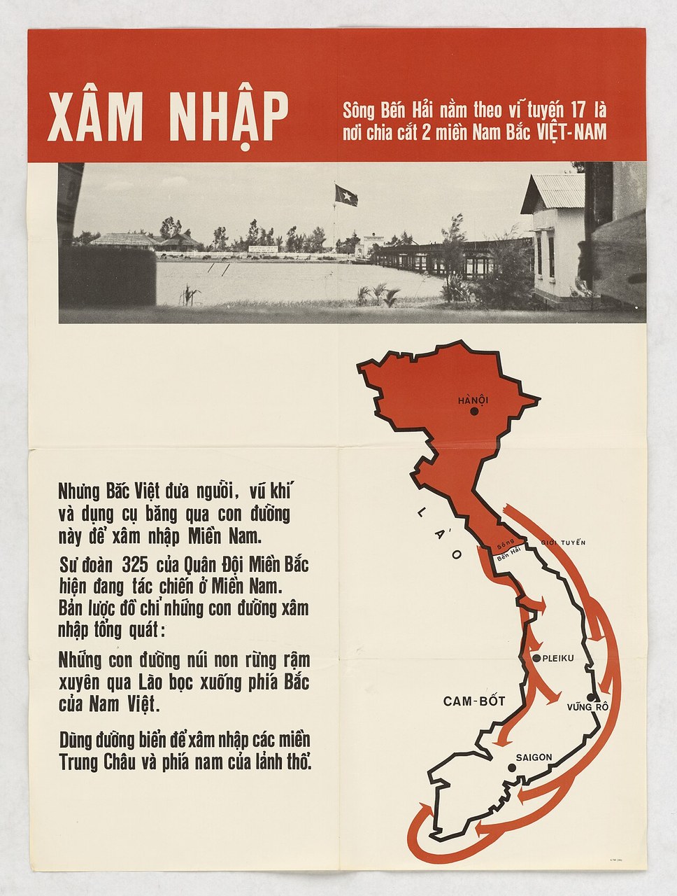
A JUSPAO poster headed 'Infiltrate' pairs a photograph of the Ben Hai river bridge at the 17th parallel, with a flag flying on the northern bank, and a map of Vietnam with the northern half filled in red. Red arrows run south through Laos and by sea to named points. The text states that North Vietnam sends men and weapons across and that the North's 325th Division is fighting in the South. The map shows only the routes in one direction, and the sheet cites no source for its claims.
- Date
- 1965
- Period
- Cold War
- Made by
- Joint U.S. Public Affairs Office (JUSPAO) printing section, for the South Vietnamese government
- Region
- North America
- Country
- United States
- Medium
- Poster
- Issuer type
- State
- Regime
- Johnson Administration
- Leader
- Lyndon B. Johnson
- Audience
- Foreign public
- Purpose
- Persuade or win support
- Theme
- War and the military
- Event
- Vietnam War
- Techniques
- Card stacking
- Source
- Unidentified Source blurred: contractors, cutouts, buried disclosure
- Source
- U.S. National Archives (NARA), via Wikimedia Commons (DPLA); NAID 26326296, retrieved October 2, 2026
- Rights
- Public domain (U.S. government work; Commons PD-US, PD-South VietnamGov; NARA NoC-US)
U.S. Information Agency, Joint U.S. Public Affairs Office (JUSPAO); National Archives, Records of the U.S. Information Agency (RG 306).
Text on the object
XÂM NHẬP

Sông Bến Hải nằm theo vĩ tuyến 17 là nơi chia cắt 2 miền Nam Bắc VIỆT-NAM

Nhưng Bắc Việt đưa người, vũ khí và dụng cụ băng qua con đường này để xâm nhập Miền Nam.

Sư đoàn 325 của Quân Đội Miền Bắc hiện đang tác chiến ở Miền Nam. Bản lược đồ chỉ những con đường xâm nhập tổng quát:

Những con đường núi non rừng rậm xuyên qua Lào bọc xuống phía Bắc của Nam Việt.

Dùng đường biển để xâm nhập các miền Trung Châu và phía nam của lãnh thổ.

Map labels: HÀNỘI; LÀO; Sông Bến Hải; GIỚI TUYẾN; PLEIKU; CAM-BỐT; VŨNG RÔ; SAIGON

[illegible — print code at lower right]
INFILTRATE

The Ben Hai River, lying along the 17th parallel, is where the North and South of VIET-NAM are divided.

But North Viet[nam] sends people, weapons and equipment across this road to infiltrate the South.

The 325th Division of the Northern Army is at present fighting in the South. The sketch map shows the general infiltration routes:

The mountain and dense-forest roads through Laos curling down to the north of South Vietnam.

Sea routes are used to infiltrate the central delta regions and the south of the territory.

Map labels: Hanoi; Laos; Ben Hai River; Demarcation line; Pleiku; Cambodia; Vung Ro; Saigon
Machine translation by Claude, not verified by a fluent reader. 'Bắc Việt' is rendered 'North Vietnam' as the poster uses it for the North's government and army. The printed code at the lower right edge is too small to read.