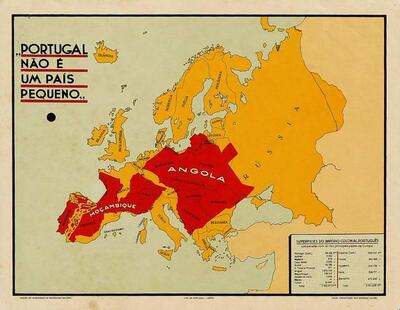
Portugal não é um país pequeno (Portugal is not a small country)
Colour lithograph map that lays the outlines of Angola, Mozambique and the other Portuguese overseas territories over a map of Europe, in red, with a table of areas compared with those of European countries. The tell: the comparison uses area alone, so the territories' extent is shown without population, wealth or the question of who lived there.
- Date
- 1934
- Period
- Interwar
- Made by
- Secretariado da Propaganda Nacional (SPN), Lisbon; map organised by Henrique Galvão
- Country
- Portugal
- Medium
- Issuer type
- State
- Regime
- Estado Novo
- Audience
- Domestic public
- Purpose
- Persuade or win support
- Techniques
- Card stacking
- Source
- Identified Openly sourced: the speaker is who they say they are
- Source
- Portuguese Army Library (Biblioteca do Exército), Arquivo Digital da Defesa, via Europeana, retrieved October 2, 2026
- Rights
- Public Domain Mark 1.0, as stated by the Portuguese Army Library and Europeana
Biblioteca do Exército (Portuguese Army Library), Arquivo Digital da Defesa, via Europeana record 10501/bib_rnod_272266.
Text on the object
PORTUGAL NÃO É UM PAÍS PEQUENO
SUPERFÍCIES DO IMPÉRIO COLONIAL PORTUGUÊS comparadas com as dos principais países da Europa
[illegible: area table]
ANGOLA
MOÇAMBIQUE
RÚSSIA
PORTUGAL IS NOT A SMALL COUNTRY
AREAS OF THE PORTUGUESE COLONIAL EMPIRE compared with those of the main countries of Europe
[illegible: area table]
ANGOLA
MOZAMBIQUE
RUSSIA
The subtitle is taken from the library's catalogue note, which quotes the printed legend at lower right; the table is too small to read at 400 px. Translation is a machine translation by Claude, not verified by a fluent reader.